ADVENTURE
AIDS
AIRLINES
AIRPORT
AIRPORT BUS
ARCHAEOLOGY
ARCHITECTURE
ARCHIVES
ART GALLERIES
BANKS
BIRDING
BOOK EXCHANGE
BUDGET TRAVEL
BUSES
BUSHFIRE
BUSHMAN PAINTINGS
BUSHMEN
CAMPSITES
CAR HIRE
CARS and DRIVING
CATTLE
CLIMATE
COLONIALISM
CRIME
DRUGS
ECONOMY
HISTORY
IMMIGRATION
KINGS
MBABANE
NATURE RESERVES
POLICE
RITUAL CEREMONIES
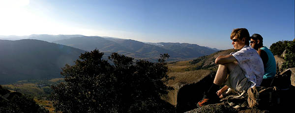
SIBEBE TRAILS
TOUR COMPANIES
TRAVEL AGENCIES
Index to information in the guide
Sibebe is arguably the world’s largest single granite rock, for basic details of the geology see the Sibebe entry. As far as hikers are concerned it is certainly a superb highly accessible area which is extremely beautiful. The Sibebe community have set up a reception center towards the end of Pine valley, one of the valleys that branches out from Mbabane. To get there look at the Mbabane map which will take you to the start of the valley and then simply follow the large clear signposts until you reach it at the end of the valley. If you run out of tar you have overshot the reception by a hundred meters. If you are going by bus you should ask for Mbuluzi School, which is opposite the reception area.
The trail starts at reception and wends its way up the vast granite domes you should allow about three quarters of an hour to get to the top, it all depends on how fast you walk and how often you stop to pretend to look at the view. The route is marked by cairns and white markers, it is not difficult to find the way. Do not attempt this in summer if it looks as though there is mist descending, this can be dangerous. You should allow at least four hours for the expedition and work backwards from sunset so that you do not get marooned up there. If you do, there are numerous caves to explore and keep dry in if it rains. Do not try coming down at night.
Once on top the scale of the single rock becomes apparent, this is a truly vast geological phenomenon, the top is flat. Or rather there is a plateau with a stream running through it and wild horses graze in the distance. Sometimes they spook and you see horses running free and wild, their manes blowing in the wind.
There is a route on the top, if you walk along the edge you get sweeping views over Pine Valley and the walking is easy, the paths are clear and the surface is smooth. It is very beautiful. You will cross small streams of clear drinkable water and - depending on the time of year - you may see carpets of wildflowers. These are best in spring after fires and rain, so the timing is variable, but October to December will have flowers.
You do not need to book for this, the reception is open all year, but might be a bit erratic on Christmas and New Year’s days. Remember to take water and sunblock. Highly recommended.